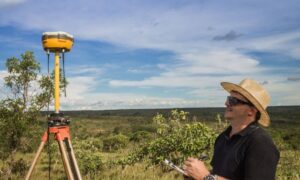
Why LiDAR Is a Game-Changer in Land Surveying
In today’s fast-moving world of construction and infrastructure, surveyors need tools that are not just accurate—but fast, reliable, and safe too. That’s where LiDAR mapping is stepping in to make a real difference. Short for Light Detection and Ranging, LiDAR uses laser technology to measure the earth’s surface and create detailed 3D models.
Once considered cutting-edge, LiDAR is quickly becoming the standard for many land surveying projects. Whether you’re planning a highway, mapping a forest, or managing a construction site, this tech brings serious benefits to the table.
Let’s look at the top 7 reasons surveyors are turning to LiDAR for their most important jobs.
1. Exceptional Accuracy and Precision
Accuracy matters in surveying—and LiDAR delivers. With the ability to collect thousands of measurements per second, LiDAR produces incredibly detailed point clouds. These data points can be used to create high-resolution terrain models, often accurate down to just a few centimeters.
Even in thick forests or rugged terrain, LiDAR can “see through” to the ground. That makes it ideal for topographic surveys, especially in areas where traditional tools might struggle.
2. Rapid Data Collection Over Large Areas
One of the biggest benefits of LiDAR in surveying is how quickly it can scan huge spaces. What might take a team of surveyors several days—or even weeks—with GPS or total stations, LiDAR can complete in just hours.
This is especially valuable for large-scale projects like:
- Highways and roads
- Utility corridors
- Environmental assessments
Faster data collection means faster project timelines, without sacrificing accuracy.
3. Enhanced Safety for Surveyors
Surveying often takes place in hazardous conditions—think highways, cliffs, wetlands, or construction zones. With LiDAR, much of the data can be captured remotely, reducing the time crews spend in risky environments.
Surveyors can use LiDAR sensors mounted on drones or vehicles, keeping workers at a safe distance while still collecting everything they need.
4. High-Density 3D Point Cloud Output
LiDAR mapping doesn’t just collect a few data points—it gathers millions. These dense point clouds can be processed into detailed 3D models that show terrain, elevation, and built structures.
With the right software, surveyors can:
- Generate contour maps
- Analyze slope and elevation
- Export to CAD or GIS for further design
The result? Better planning and fewer surprises during construction.
5. Versatility Across Terrain and Conditions
Unlike some technologies that only work on flat or open land, LiDAR performs in nearly all environments. It’s effective in:
- Forested areas
- Mountainous terrain
- Urban streetscapes
- Coastal and floodplain zones
The laser pulses can penetrate vegetation, making it possible to gather elevation data even under thick tree cover.
6. Seamless Integration with UAVs and Drones
Thanks to drone technology, surveyors no longer need to hike rough terrain with equipment on their backs. LiDAR sensors mounted on UAVs (unmanned aerial vehicles) can fly over an area and scan it in minutes.
This method is perfect for places that are difficult or dangerous to access, and it delivers fast, accurate data straight to the computer for processing.
7. Cost Efficiency for Long-Term Projects
At first glance, LiDAR systems may seem expensive. But when you factor in the reduced labor, shorter timelines, and fewer repeat visits, the long-term savings are real.
For big projects—especially those with tight schedules—LiDAR can:
- Reduce overall survey time
- Minimize human error
- Deliver better results with fewer field revisits
This means better budgeting and smoother workflows for developers, engineers, and contractors alike.
Use Cases: Where These Benefits Matter Most
These advantages aren’t just theoretical. Here’s where LiDAR mapping is making a real difference:
- Transportation Projects: Plan, grade, and monitor roads with high-accuracy digital terrain models.
- Construction Sites: Track progress, check elevations, and avoid rework.
- Environmental Studies: Map watersheds, study erosion, and assess flood risk areas.
No matter the industry, LiDAR is helping teams work smarter—not harder.
FAQs
1. Is LiDAR better than GPS for land surveying?
It depends on the project. GPS works well for small or open areas, but LiDAR shines in complex terrain or larger sites.
2. Does LiDAR work in forests or overgrown land?
Yes! That’s one of its strengths. LiDAR can often measure ground elevations even through dense vegetation.
3. Can LiDAR be used indoors?
While it’s mostly used outdoors, some indoor scanning applications are possible with ground-based LiDAR systems.
4. How long does it take to process LiDAR data?
Processing can take a few hours to a few days depending on the area size and software used.
5. What software do surveyors use with LiDAR?
Common tools include Civil 3D, Global Mapper, LAStools, and various GIS platforms.
6. Is drone-based LiDAR legal?
Yes, but drone flights for commercial surveying must follow local aviation rules and require licensed operators.
Final Thoughts: Upgrade Your Surveying Game with LiDAR Technology
If you’re a land surveyor, contractor, or project manager, there’s no denying the impact of LiDAR on modern surveying. From faster data collection to greater safety and precision, the technology has proven itself time and time again.
Whether you’re surveying a busy construction site or a remote mountainside, the benefits of LiDAR in surveying are clear. It’s efficient. It’s versatile. And it’s here to stay.
